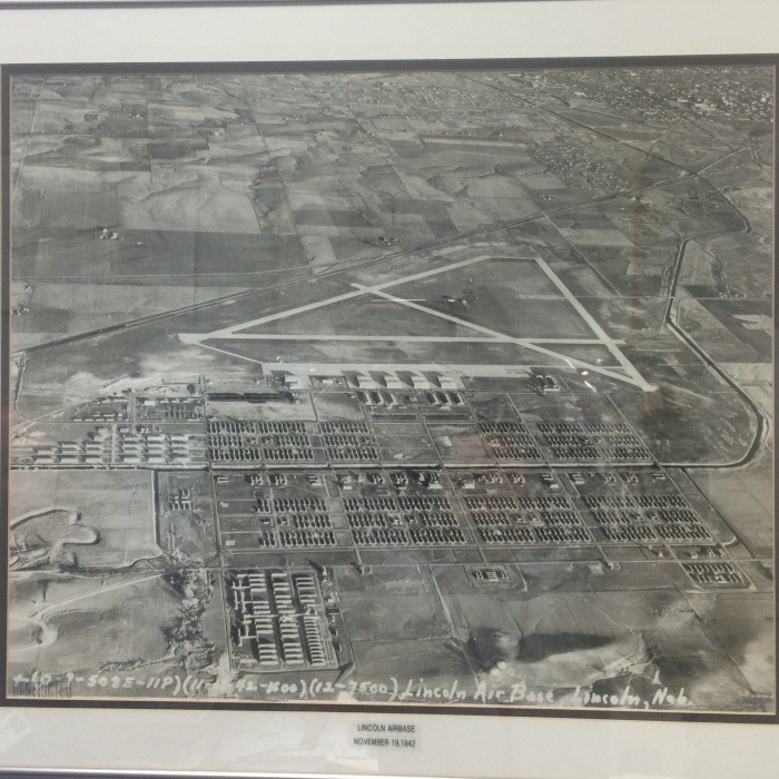
A photo showing the Lincoln Army Air Base on November 19, 1942, looking East. No aircraft appear to be stationed here as of yet. At this point Oak Creek has been redirected to run parallel with the main North/South road, which today is named NW 38th Street. The four main aircraft hangars are in place, as well as the church. Several barracks are set up on both sides of the creek. Huskerville is shown in the lower left section of the photo. The Southern most road is currently West Mathis Street, named after Jack W. Mathis. The streets were named after MOH recipients during the Lincoln AFB days. The road that runs southwest to northeast is now located within the airport boundary. A section of this road is still there and is used as an airport access road. After the base was closed, the barracks were sold off at auction and bought up my many farmers to use for storage, etc. Arnold Elementary School is now built where Huskerville used to be located. Oak Creek was again redirected during the 1950’s to make room for a longer runway when the air force base was constructed. The east road and railroad tracks were moved during the 1950’s, too. The last two remaining storage buildings, located in the left center of the photo, were removed just a few years ago. The City of Lincoln can be seen in the upper right of the photo as well as West Lincoln.